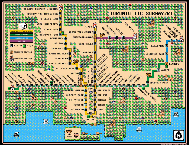
Toronto TTC Subway/RT Map - Super Mario 3 Style
UPDATE: The poster has been updated to include the Y-U-S extension (opening 2014), by popular demand. A few other fixes and additions were implemented too.
Buy a poster of this image here. 300 dpi. Spared no expense. (Update: If you ordered on June 13th you got the older version. You can ask Imagekind for a free replacement featuring the updated map above).
Calgary C-Train Vancouver Skytrain
This is the first time I attempted a Mario 3 Rail map for a city I haven’t lived in. I initially set out to do this last year, but every map I saw was too wide. I then saw a compressed map online a few weeks ago and decided to emulate that.
So…Montreal next?
Posted on June 12, 2012, in Art, Map, Transportation, Video Games and tagged Calgary, Map, mario 3, Nintendo, Toronto, Video Games. Bookmark the permalink. 9 Comments.


Saw this posted on BlogTo this morning. Pretty awesome! Good work!
Yorkdale has GO. Otherwise, awesome!
Blame lies with Wikipedia (something I say everyday): http://en.wikipedia.org/wiki/Toronto_subway_and_RT#System_map
A lot of the stations have GO. The map you based it off shows the train links (which also have buses). Stations like Yorkdale, York Mills, Finch, etc only have GO bus hubs. Just change the word “Go” to “Go Train Link” and you’re all set! I wouldn’t try figuring out the Go Bus links, there are too many!
Great map!
Montreal would be great! Though I’m a Torontonian, I think Montreal’s system is much better! This, and your previous work, is fantastic!
Would love a shower curtain version of this!
Pingback: TTC Meets Mario 3 | cityscape | Torontoist
Pingback: Super Mario 8-bit video game meets TTC subway map | mariocars.com
Pingback: Super Mario-style Skytrain map | Habilis