
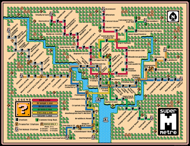
You can buy a high-res poster here.
(UPDATE - July 4th 2019): The Silver Line station names have been updated, a few trees were trimmed as well. Please email me or contact me on social media if there are any changes to any of my maps.
You can buy a high-res poster here.
(UPDATE - July 4th 2019): The Silver Line station names have been updated, a few trees were trimmed as well. Please email me or contact me on social media if there are any changes to any of my maps.


What tools did you use to make this? I’d love to do a Manhattan subway map. Think it’s impossible?
I have something planned for NYC, but it would involve a crowdfunding campaign to support. It’s very ambitious.
I would help. This is amazing and as an NYC resident, I’d die to have this on my office cubey 🙂
I’m in with that!
Please do Toronto!!!! You would have so many buyers!
I did one for Toronto last year, It has been a success! Here it is: https://davesgeekyideas.com/2012/06/12/toronto-ttc-subwayrt-map-super-mario-3-style/
Is New York not possible? Too busy?
I’d buy one of NYC. Nostalgia!
NYC is possible for this style, it would just be massive. I have something else in mind for NYC…
This is going in my cube at work. Makes me homesick for sure! Tampa, get some trains will ya!?
Do St. Louis please!
Minneapolis please!!! This is GREAT!
Portland! I don’t think that would be too crazy. This is so great.
Any chance you would do Los Angeles MTA’s system? Both the current system and the one slated to be done at the End of Measure R?
Is there any way to purchase just a high-rez original image of this DC map? It’s amazing, and I wanna put it on a custom shower curtain!
Sorry, the high-res versions stay with me.
Philadelphia has a subway and an elevated subway it also connects to a Southern NJ line. It would work as a Super Mario map.
This is so awesome…ordered a big one to frame and put in my cave!
Are you sure Boston wouldn’t work in this? Sure, the Green Line’s probably too complex once it splits outbound, but most official maps simplify that anyway.
Tacoma is misspelled. Sadface.
Ugggh… ignore me. I’ve been living on the west coast too long. Nothing to see here.
Would you consider printing this on a clear shower curtain? I’m currently using one that is a map of the metro but it doesn’t have the Silver line.
Don’t sell shower curtains, no idea how you got that.
Is there a tool to use the mario style graphics like this, or was it extracted by hand?
No tool, built it myself. Had to blow-up and redraw all the sprites to fit a huge 300dpi poster.
There have been some updates to DC can you update your map so when I buy my print its current.
https://www.washingtonian.com/2022/09/09/5-metro-stations-will-get-new-names-this-weekend/#:~:text=%20Starting%20on%20Sunday%2C%20five%20stations%20across%20Maryland,name%20from%20VT%2FUVA%20to%20VT%20only.%20More%20
Please update to the current map